Terrain of Shinyanga-
 The region is located in a drought prone area Northwest of Tanzania, about 1,500 meters above sea level. The region has a total of 50,264 square kilometers. The forest covers 4% of the land; bush covers 29% of the land; and the remaining 67% is used for agriculture and grazing.
Climate in Shinyanga –
 The average daily temperature is between 20 to 25 degrees celcius. High temperatures can range anywhere from 30 to 38 degreees celcius.
Shinyanga receives 600mm to 1000mm rainfall per year in two distinct seasons. The short rain season begins in late October and continues into mid December. The long rain season lasts from mid February to late May.
Agriculture in Shinyanga-
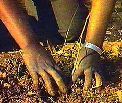
 Environmental destabliization is a major constraint to increased agricultural production, forest products and food security in the region. Deforestation exacerbated by excessive grazing, poor farming methods, shifting cultivation, population pressure and uncontrolled cutting of trees have reduced soil fertility, lowered water tables and increased scarcity of products for cooking and building.
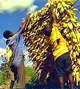 The predominant food crops of the Shinyanga region are maize, cassava, paddy, groundnuts, sweet potatos, and sorghum. Cotton is grown extensively as a cash crop.
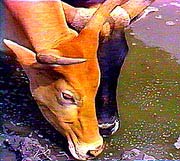 Cattle, which outnumber humans by a ratio of 3 to 1, is the main source of income and wealth. They are used as dowries in addition to agriculture.
Natural Resources of Shinyanga-
 Many different types of wildlife can be found in the Shinyanga region, including zebras, elephants, hippopotamus, giraffes, lions, and monkeys.
Gold and diamonds are the main mineral found in the region and are mined for export. Diamonds make up about 24.3% of the total mineral for export in the country.